Forest operations · Working MVP
Internal R&DLive command system for forest divisions
One screen for a forest division's control room: guards, vehicles and drones live on the division map, with live, stale and offline status, offline sync that loses nothing, role-based access and a Hindi and English interface. The MVP runs today; incident dispatch and the field apps are next.
The problem
A forest division today runs on separate pieces that do not talk to each other. Satellite fire alerts arrive by SMS with a coarse location a few times a day. The drone pilot flies with the manufacturer's app on a phone, and nobody else sees the feed. Guards' patrol tracks appear only after they sync, hours later. Vehicles are tracked by a separate vendor, or not at all. Coordination happens over phone calls and messaging apps, and leaves no record of how long a response took.
What I built
A working MVP of the control-room side. Guards, patrol vehicles and drones appear live on the division map over satellite, terrain or street base maps, with beat boundaries, forest roads and fire lines as layers. Every asset shows live, stale or offline status with battery and last-seen time, and an asset that stops reporting is flagged rather than silently frozen. When a guard walks out of mobile coverage, the track keeps recording and uploads when the signal returns, so the patrol history has no gaps and no duplicates. Access is role-based, down to range level, and the whole interface switches between Hindi and English. The demo video runs on demo data: the boundaries near Mandi are illustrative, and field devices are simulated through the same interface real phones and trackers will use.
How it works
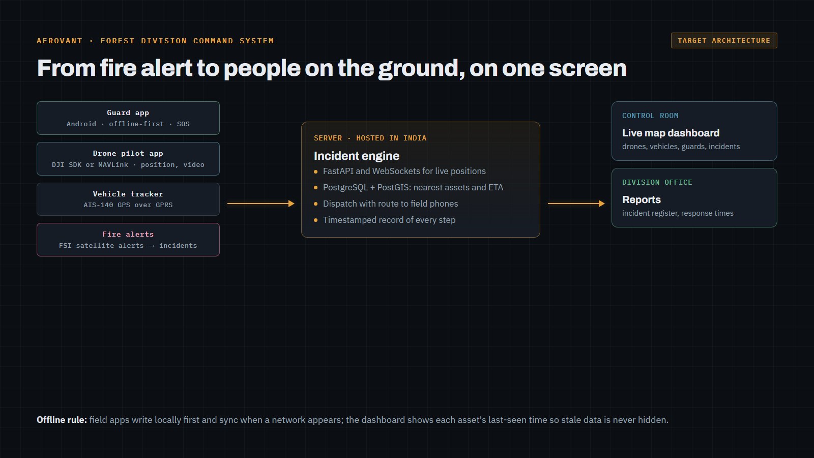
A Python FastAPI server pushes live positions to the dashboard over WebSockets, and PostgreSQL with PostGIS stores positions and boundaries for spatial queries. The dashboard is built on MapLibre with cached base maps. Field devices write locally first and upload when a network appears, and the dashboard always shows how stale each position is. The diagram shows the target architecture, including the parts still to come: drones connected through a pilot app (DJI Mobile SDK, or MAVLink for other autopilots), vehicles through AIS-140 GPS trackers, and satellite fire alerts turned into incidents. The system is designed to be hosted in India, on government-approved cloud or on-premise.
Outcome
The MVP runs end to end on demo data, as shown in the video. Next: the guard mobile app (patrol and SOS), the Mavic Air 2 link with live video, incidents that rank the nearest team and dispatch them, FSI fire alerts arriving as incidents, and incident and patrol reports as PDF. It is not yet deployed with a forest division.
Working on something similar? You'll talk to the engineer who builds it.
Start a project